

Some Great Day Hikes in Aotearoa
Discover the best day hikes in Aotearoa, New Zealand! From short jaunts to full-day adventures, explore our stunning landscapes on foot. Whether you're a beginner or an experienced tramper, find your perfect hike here.
This page may contain affiliate links. Read our disclosure policy for more info
Unique New Zealand Hikes
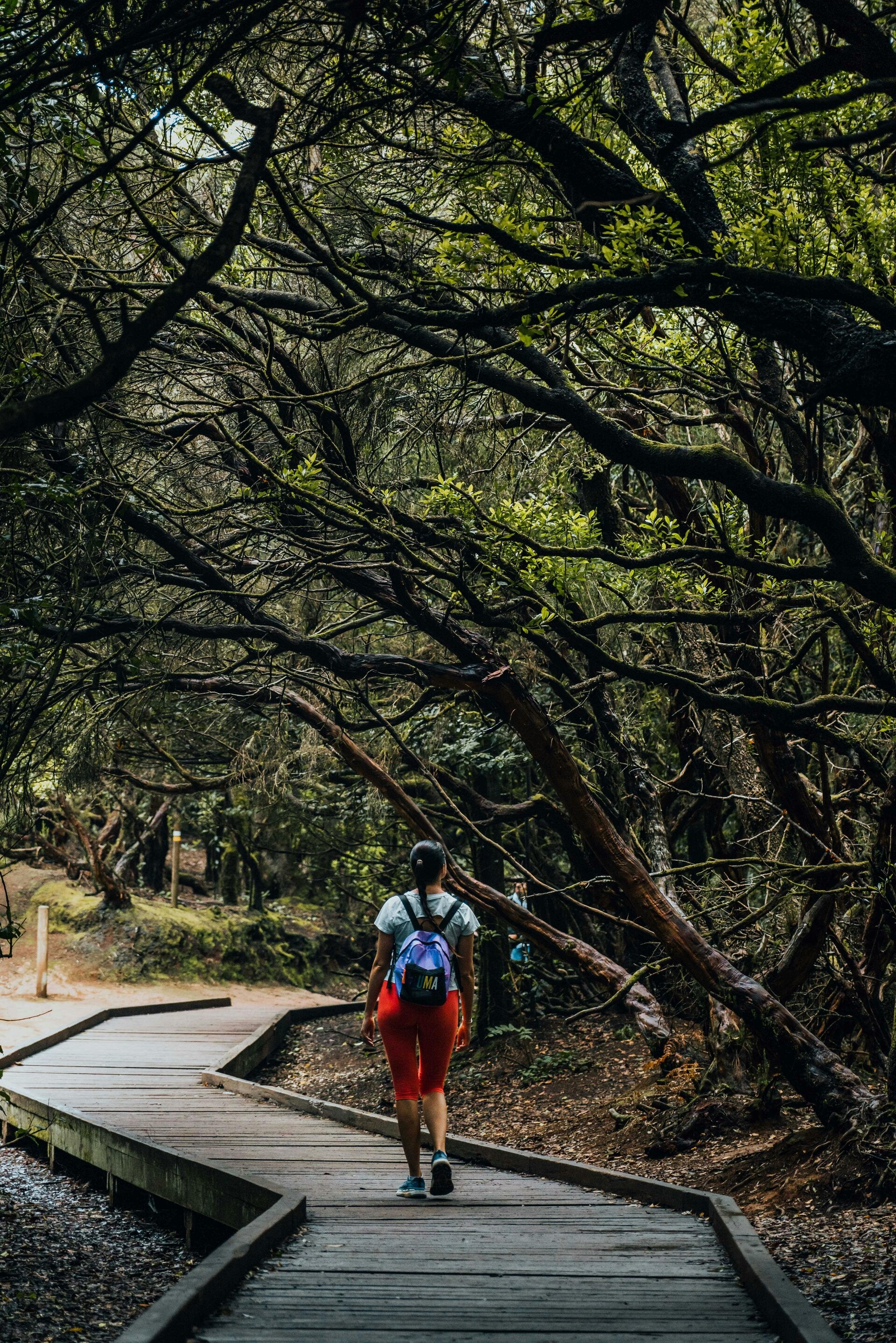
What sets a day hike in New Zealand apart? It's the unique blend of pristine wilderness, diverse ecosystems, and well-maintained tracks. Expect encounters with native birds, lush rainforests, volcanic landscapes, and breathtaking coastal views that you won't find anywhere else.

Hikes For Everyone
This page caters to a wide range of hikers, from beginners and families looking for accessible trails to experienced trampers seeking challenging climbs. We aim to provide options and advice for all fitness levels and interests, ensuring everyone can enjoy the beauty of Aotearoa's tracks.
Popular Day Hikes
Some of New Zealand's most popular day hikes include the Tongariro Alpine Crossing (challenging but rewarding), the Hooker Valley Track in Aoraki/Mount Cook National Park (easy and accessible with stunning mountain views), and the Abel Tasman Coast Track (coastal paradise). These hikes offer incredible scenery, well-maintained paths, and unforgettable experiences. Always check weather conditions and track closures before heading out!
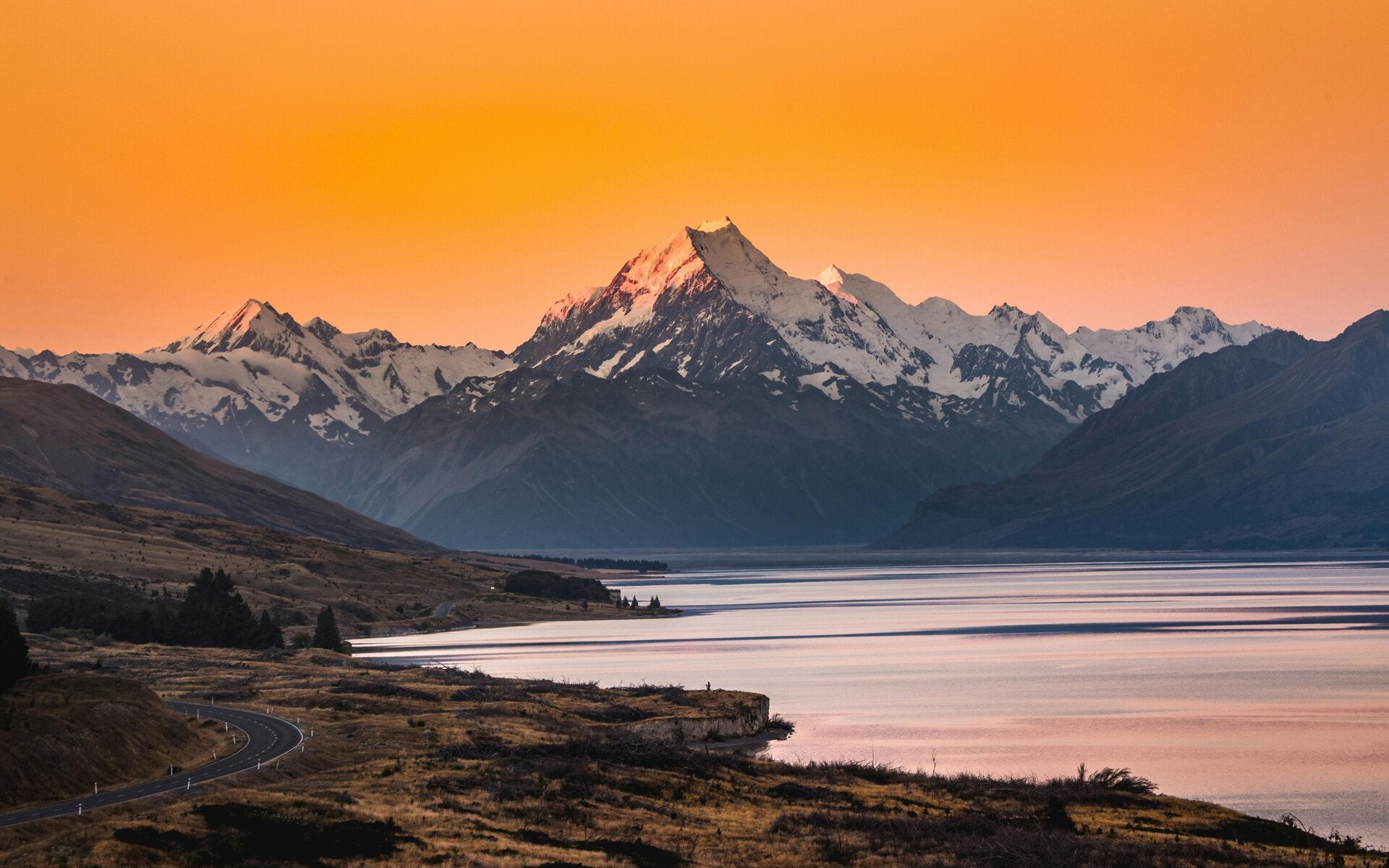
Hooker Valley Track — Aoraki/Mt Cook
Vibe: Big-mountain drama for minimal effort. Boardwalks, swing bridges, glacier views.
Quick facts: 10km return • ~3 hrs • Easy • From White Horse Hill car park (near Mt Cook Village)
If you’ve only got one alpine walk in you, make it this. The trail is wide and well-graded, with three swing bridges and constant “wait, that’s real?” views of Aoraki/Mt Cook. You’ll end at Hooker Lake where icebergs bob around like giant marshmallows. On a calm day the reflections are ridiculous.
How to do it right
- Best time: Sunrise and late arvo light up the peaks. In summer, start early to beat heat and crowds.
- What to bring: Wind/rain layer even if the sky’s blue, hat, sunscreen—the UV here is no joke.
- Where to base: Mt Cook Village (walkable to the trailhead) or Tekapo (1 hr away). The Hermitage has views for days; the YHA-style lodges are great value.
- Photo spots: After the second swing bridge looking up the valley, and the lakeshore rock shelf at the end.
Local tip: Kea (alpine parrots) are cheeky. Don’t feed them and watch your unattended snacks.
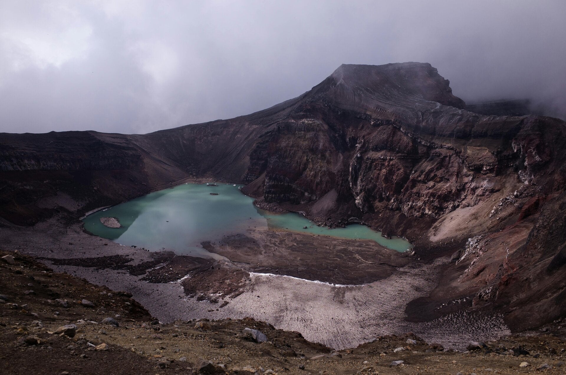
Tongariro Alpine Crossing — Ruapehu
Vibe: Moon meets Middle-earth. Craters, steam vents, emerald lakes.
Quick facts: 19.4km one-way • 6–8 hrs • Challenging • Book a shuttle (Mangatepopo → Ketetahi)
This is NZ’s poster-child day hike and it earns the hype. You’ll climb past the red crater (yep, it’s active), skip across alpine saddles, and stare into electric-green lakes. It’s exposed and can be windy—exactly why it feels epic.
How to do it right
- Logistics: Park at Ketetahi and shuttle to Mangatepopo so your car is waiting at the end. Book ahead in summer.
- Best time: December–April. Outside this window you’ll need alpine skills and winter gear.
- What to bring: 2–3L water, serious sun protection, warm layers, snacks that make you happy.
- Pace yourself: The Devil’s Staircase is a leg burner; take it steady.
- Where to stay: Whakapapa Village or National Park Village for easy shuttle access.
Local tip: Weather calls get made early. If operators cancel for safety, roll with it—go do Taranaki Falls or Tama Lakes instead.
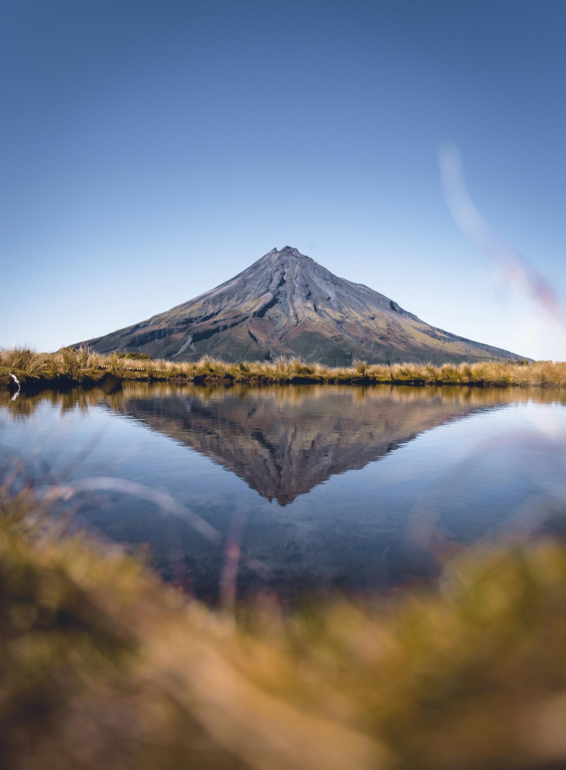
Pouakai Crossing — Taranaki
Vibe: Boardwalks over alpine bogs, gobsmacking views of Mt Taranaki, mirror-perfect tarns.
Quick facts: ~19km one-way • 7–9 hrs • Moderate–Challenging • Shuttle recommended
If you want Tongariro-level drama without the masses, this is your move. When the wind is still, Mt Taranaki reflects in the Pouakai Tarns like it’s posing for a magazine cover. Forest, tops, and wetlands—great variety in one hit.
How to do it right
- Best time: Early morning for glassy tarns. Autumn and winter give clearer air; summer brings longer light.
- Logistics: Many do it one-way with a shuttle; others turn at the tarns and backtrack.
- What to bring: Gaiters or spare socks—boardwalks can be slick, and it’s a boggy environment.
- Where to base: New Plymouth or Egmont Village; grab a celebratory bite on the Coastal Walkway afterwards.
Local tip: If the mountain’s wearing a cloud hat, hang out for a bit—conditions change fast here.
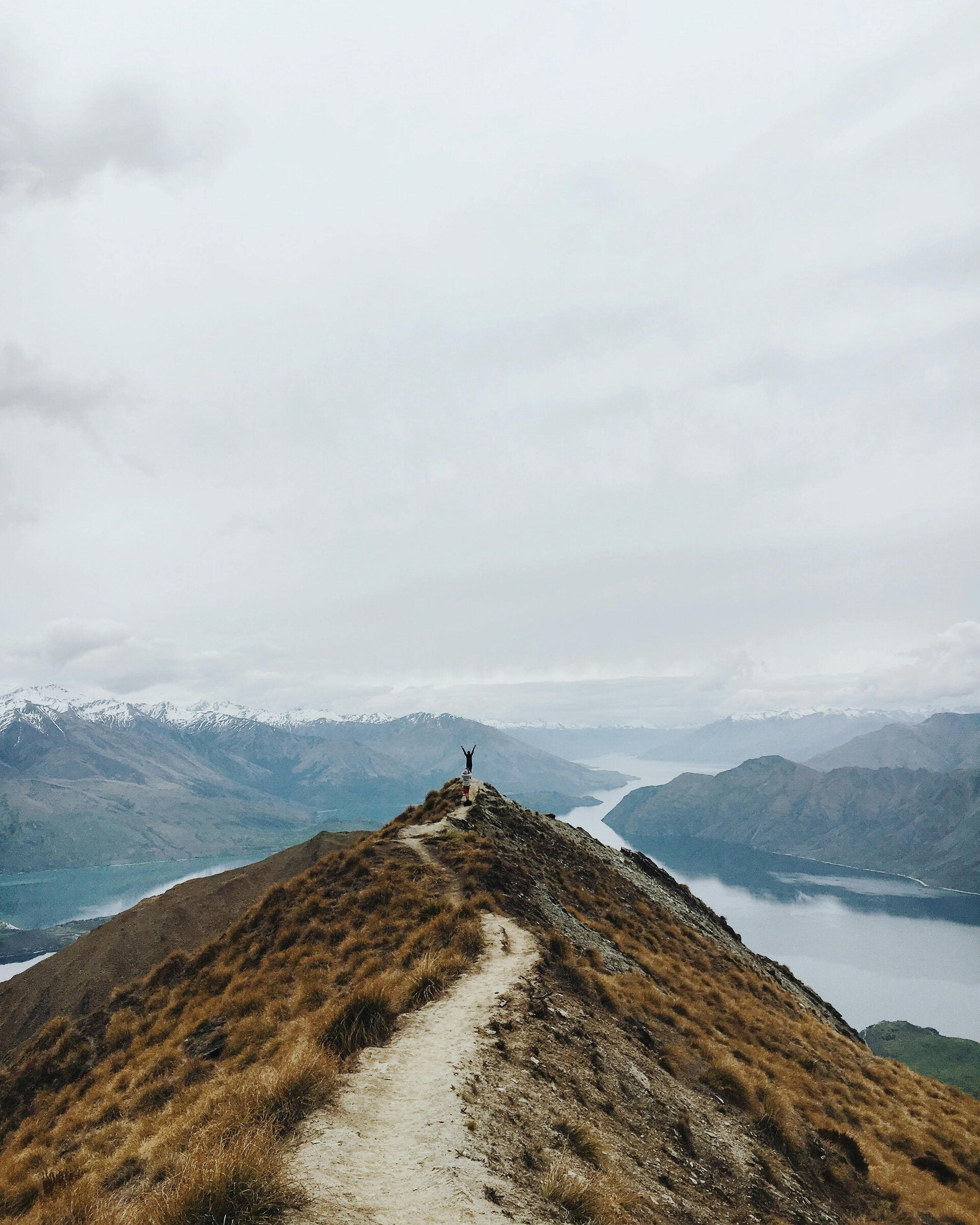
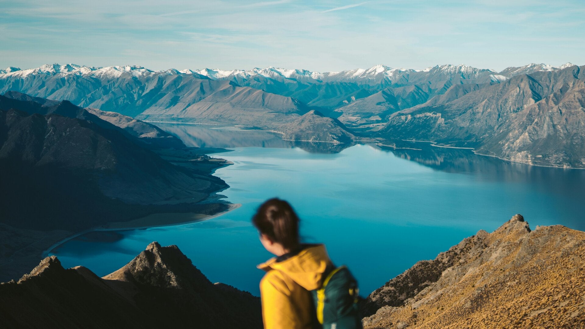
Roy’s Peak / Isthmus Peak — Wānaka
Vibe: Sweeping lake-and-ridge views, steady switchbacks, big reward.
Quick facts:
- Roy’s Peak: 16km return • 5–7 hrs • Strenuous • Seasonal lambing closure (usually Oct–Nov)
- Isthmus Peak: 16km return • 5–7 hrs • Strenuous • Often quieter
Roy’s Peak is the classic Wānaka shot. It’s a straight-up grunt on a farm track to a skyline ridge. Isthmus Peak serves a similar payoff overlooking both Lakes Wānaka and Hāwea, with fewer people.
How to do it right
- Start early: Car parks fill before 8am in summer. Sunrise is magic and cooler.
- What to bring: Poles help on the descent; there’s zero shade—pack sun gear and 2L water.
- Where to base: Wānaka town (cafés, lake swims).
- Food: Reward run: Big Fig, Francesca’s, or a lakeside gelato.
Local tip: If Roy’s is rammed, pivot to Isthmus or Rocky Mountain / Diamond Lake for a shorter, varied option.

Ben Lomond — Queenstown
Vibe: Proper summit day above a resort town. Tussock slopes, alpine saddle, 360° panorama.
Quick facts: 14–18km return (depending on start) • 6–8 hrs • Strenuous • Start via Skyline or One Mile
From Queenstown you climb into open country and tag a real summit. If you take the Skyline gondola up/down, you shave off some forested grind; otherwise start at One Mile for a purist’s ascent.
How to do it right
- Season: Summer/early autumn is best. In shoulder seasons, snow/ice can linger—check conditions.
- What to bring: Layers, gloves, windproof shell. It’s often colder up there than you think.
- Where to base/eat: Queenstown. Post-hike, Fergburger or a lakeside pizza hits the spot.
- Bonus: Wildflowers in late spring; stars are crisp if you descend at dusk.
Local tip: The saddle is a sensible turnaround if weather’s sketchy—views are already superb.

Key Summit — Fiordland (Routeburn side trip)
Vibe: High payoff for low commitment. Alpine tarns, boardwalk loop, Fiordland walls.
Quick facts: 8km return • 3 hrs • Easy–Moderate • Starts at The Divide (Milford Rd)
This is the Routeburn’s teaser trailer. A steady climb lands you on an alpine plateau with a short nature loop and huge views toward the Hollyford and Darran ranges.
How to do it right
- Best time: Clear mornings; Fiordland clouds often build later.
- What to bring: Rain shell—Fiordland is rain capital. Sandfly repellent.
- Where to base: Te Anau (accommodation, cafes) or stay along Milford Road lodges if you nab a spot.
Local tip: If the car park is full, try Lake Marian or Falls Creek as plan B.

Abel Tasman (day sections via water taxi)
Vibe: Golden sand, turquoise water, gentle coastal walking, swim stops.
Quick facts: Pick a segment (e.g., Bark Bay → Anchorage, or Torrent Bay → Marahau) • 3–6 hrs • Easy • Boat one way, walk the other
This is NZ’s sunniest national park, and the track is a joy—shaded bush, headland lookouts, beach after beach. Water taxis let you customise the day to suit energy and tide times.
How to do it right
- Book ahead: Water taxis from Marahau or Kaiteriteri. Ask about tide windows for estuary crossings.
- Bring: Swimwear, towel, hat, light shoes or sandals for beach landings.
- Where to base: Marahau (sleepy, right at the trailhead) or Kaiteriteri (buzzy beach town).
- Food: Pack lunch; reward ice cream at the end.
Local tip: Crack-of-dawn departures mean quiet bays before day-trippers arrive.

Taranaki Falls Loop — Tongariro NP
Vibe: Short, varied loop to a two-tier waterfall with volcanic backdrops.
Quick facts: 6km loop • 2 hrs • Easy • Starts in Whakapapa Village
Perfect if you’re warming up for the Crossing or the weather’s marginal up high. You’ll wander beech forest, open tussock, and finish in a cool mist at the falls.
How to do it right
- Direction: Counter-clockwise gives you the falls reveal later in the loop.
- Bring: Light shell (spray at the base), a tripod if you like silky-water shots.
- Where to base: Château area/Whakapapa Village; lots of short walks nearby.
Local tip: On a clear day, snap Ruapehu and Ngauruhoe framing the valley from the upper track.

Te Mata Peak Loops — Hawke’s Bay
Vibe: Limestone ridgelines, vineyard views, easy-to-customise circuits.
Quick facts: 2–10km options • 1–3 hrs • Easy–Moderate • 10 mins from Havelock North
Pick your route—gentle valley strolls or airy ridgeline rambles—and watch the light pour across Hawke’s Bay. Sunset is a crowd-pleaser; mornings are calmer for photos.
How to do it right
- Bring: A wind layer; it funnels along the tops.
- Add-ons: Wine tasting after (Craggy Range is just down the road) or coffee in Havelock North.
- Family-friendly: Plenty of picnic tables and short loops.
Local tip: The Giant Redwoods track is a shady retreat on hot days.

Lake Matheson — West Coast
Vibe: Reflection perfection with minimal effort.
Quick facts: 2.6km loop • 1–1.5 hrs • Easy • Near Fox Glacier township
On calm mornings, Mt Cook and Mt Tasman reflect in dark lake water like a painting. Even without reflections, the boardwalk and viewpoints are lovely.
How to do it right
- Timing: Be there at dawn or within an hour of sunset for still water.
- Bring: Insect repellent (sandflies), a hot drink for those frosty starts.
- Where to base: Fox Glacier village; grab breakfast at the trailhead café when it opens.
Local tip: If it’s breezy, walk to the Jetty Viewpoint first—sometimes it’s sheltered enough to sneak a shot.

Devil’s Punchbowl — Arthur’s Pass
Vibe: Short, steep, and loud—131m waterfall with alpine beech and swing bridges.
Quick facts: 2km return • 45–60 mins • Easy–Moderate (stairs) • Just off SH73 in Arthur’s Pass Village
Ideal leg-stretcher on a Trans-Alpine road trip. The final platform puts you right in the spray—feels wild without much effort.
How to do it right
- Footwear: Grippy soles—the steps can be slick after rain.
- Pair with: Otira Viaduct lookout or cheeky kea sightings at the village car parks.
- Where to eat: Arthur’s Pass café for a pie and coffee.
Local tip: After heavy rain it’s thunderous—bring a lens cloth.

Godley Head / Awaroa–Godley Head — Christchurch
Vibe: Clifftop coastal track with WWII history, tunnels, and ocean panoramas.
Quick facts: 9–12km options • 2.5–4 hrs • Easy–Moderate • From Taylors Mistake (Sumner)
A blue-sky day here is gold: surf below, Banks Peninsula headlands ahead, and old gun emplacements you can explore (bring a small torch).
How to do it right
- Wind warning: It’s often breezy—layers and a hat that won’t take off.
- Swim stop: Finish with a dip at Taylors Mistake or Sumner Beach.
- Where to base/eat: Christchurch; grab fish and chips in Sumner afterwards.
Local tip: In winter, keep an eye out for Hectors dolphins from the cliffs.

Cape Brett (day section + boat)
Vibe: Rugged ridge walking to a lighthouse, finishing by boat through the Bay of Islands.
Quick facts: Choose a section (e.g., Oke Bay → Deep Water Cove return, or Oke Bay → Cape Brett with pre-arranged boat pickup) • 4–8 hrs • Moderate–Challenging
The trail undulates along a thin spine of land with endless blue on both sides. Doing a one-way with a boat pickup to/from Deep Water Cove or Cape Brett saves the legs and gives you that movie-moment arrival.
How to do it right
- Logistics: Book your boat well in advance; confirm pickup spots and times.
- Bring: Plenty of water—exposed and hot in summer; strong sun protection.
- Where to base: Russell or Paihia (cafés, cruises, dolphin tours).
- Photo ops: The ridge before the lighthouse is unreal.
Local tip: Calm days make for glassy coves—pack a mask and snorkel for Deep Water Cove.

Rangitoto Summit — Auckland
Vibe: Quick volcanic adventure: ferry, lava fields, pōhutukawa forest, summit views.
Quick facts: 7km return • 2–3 hrs • Easy–Moderate • Ferry from downtown Auckland
Rangitoto is Auckland’s youngest volcano and a classic half-day out. Trails weave through black lava and native forest to a big crater rim and city-harbour panorama. The lava caves spur is a fun extra (bring a torch).
How to do it right
- Ferry timing: Check last return; there’s no accommodation or shops on the island.
- Footwear: Closed shoes for sharp lava.
- Add-on: Pair with Devonport for lunch when you’re back.
Local tip: Summer weekends get busy—go early or on a weekday for quieter tracks.
Route planning & safety cheat-sheet
- Check conditions the day before: local DOC pages or i-SITE visitor centres are your friends.
- Pack the basics: 1–3L water, snacks, rain/wind shell, sun protection, map/app, small first-aid kit.
- Transport quirks: Tongariro and Pouakai often need shuttles; Abel Tasman needs water taxis; Roy’s Peak has seasonal closures.
- Leave no trace: Stay on track, take all rubbish out, respect wildlife and private land.
- Weather reality: Alpine and coastal conditions flip fast—if in doubt, turn around. The views will be there next time.
Hike Prepared
Essential advice for a safe and enjoyable day hike in New Zealand includes checking the weather forecast, wearing appropriate footwear and clothing, carrying enough food and water, packing a first-aid kit, and letting someone know your plans. Be aware of potential hazards such as changing weather, river crossings, and uneven terrain. Always respect the environment and follow Leave No Trace principles.